Recent project
Featuring A77: AI-Powered Spatial Intelligence for Engineering CAD
Projects
Stack
The Problem
AI can write code, generate reports, and reason about almost anything, but it cannot look at an engineering drawing and understand what it sees. It can't tell if two pipes are connected or just close together. It can't trace which way water flows. It can't spot a utility conflict that a junior engineer would catch in seconds.
Civil engineering drawings aren't just lines on a screen. They're spatial relationships. And spatial reasoning is the one thing LLMs fundamentally can't do.
What A77 Does
A77 is a desktop CAD application built entirely in Rust that bridges this gap. It gives engineers a full-featured drawing environment with 93 tools across pipe networks, road design, grading, and stormwater, paired with a spatial intelligence engine that lets AI actually understand the drawing.
Load a civil engineering plan, and the system runs a 13-step analysis pipeline that classifies every entity, maps how they connect, traces water flow, and checks engineering standards, then feeds all of it to the AI as structured context. The result: an AI assistant that doesn't guess. It knows.
The Brain: Spatial Analysis
Every entity in the drawing gets processed through a multi-layer classification system: metadata, layer names, color conventions, geometric reasoning, and annotation correlation. The system doesn't just see lines; it sees storm sewers, sanitary mains, road centerlines, lot boundaries.
Then it builds a Spatial Relationship Graph:
- R*-tree spatial indexing for sub-millisecond queries
- 11 deterministic topology predicates (connects, crosses, contains, parallel, drains-to, etc.)
- 3,800+ relationships detected across an entire site drawing
- Multi-core parallel processing via Rayon
- 3-layer hybrid architecture: spatial index, pattern recognition, LLM reasoning
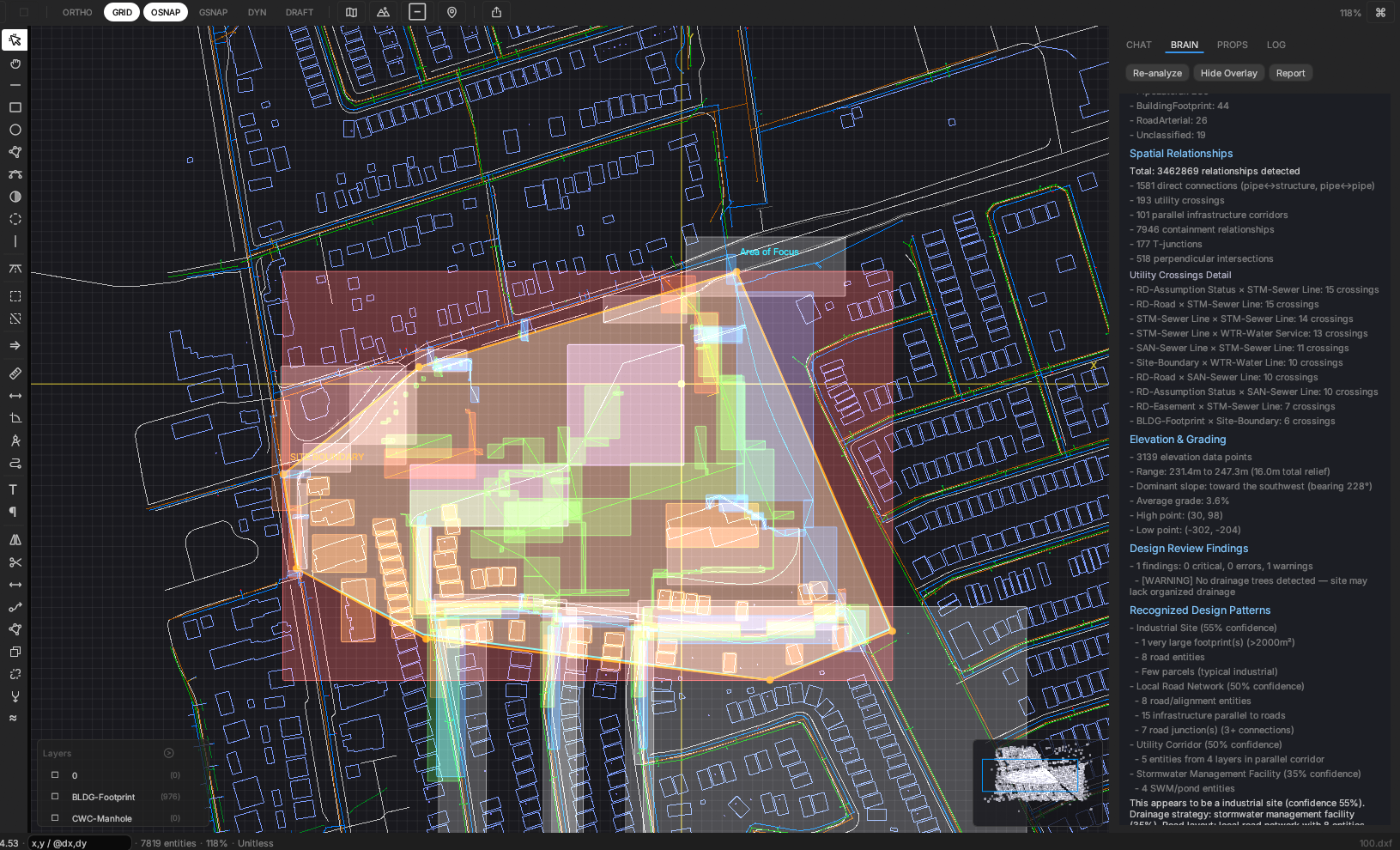
What the AI Sees
The right panel shows what the spatial intelligence pipeline produces: utility crossings with exact clearances, design pattern recognition (residential subdivision, dual drainage, utility corridors), elevation profiles, and engineering violations.
All of this becomes the AI's context. When you ask "Are there any utility conflicts?", it doesn't scan an image. It already has the exact crossing locations, angles, and separation distances.
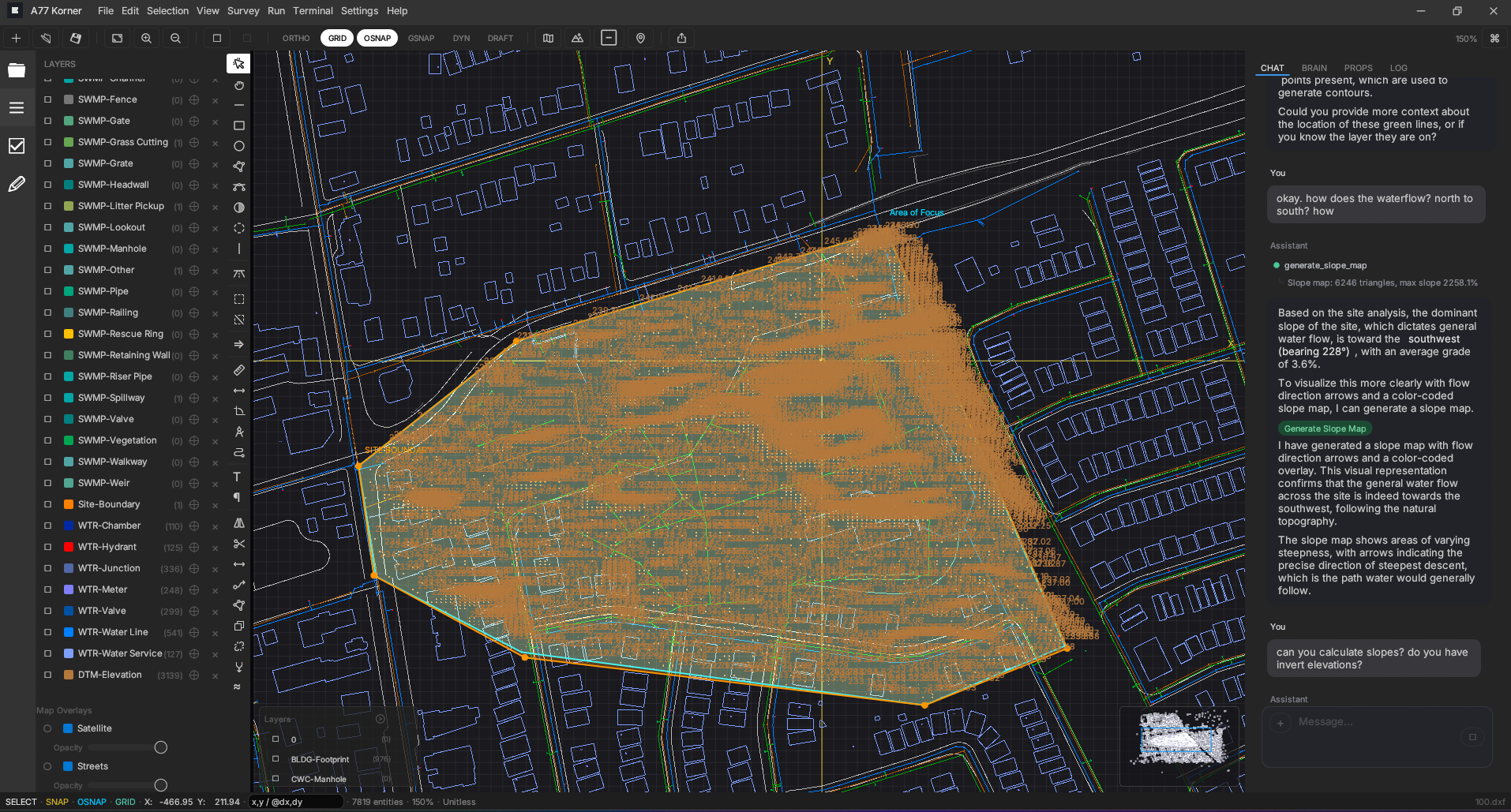
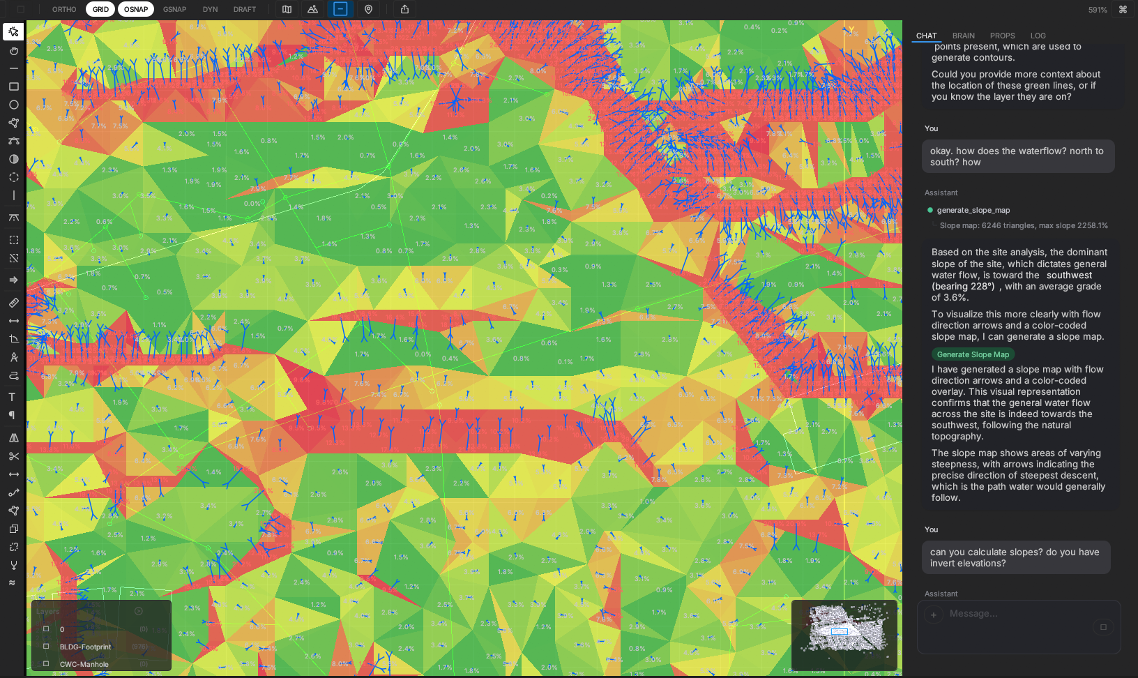
Live Terrain Intelligence
Ask the AI about a site's drainage and it reads 3,100+ elevation data points directly from the drawing. It builds a digital terrain model, calculates slopes, and identifies the dominant drainage direction, all from a chat message.
In this example, the system detected a 16m elevation drop across the site with a dominant slope toward the southwest, then generated a color-coded slope map to visualize drainage patterns.
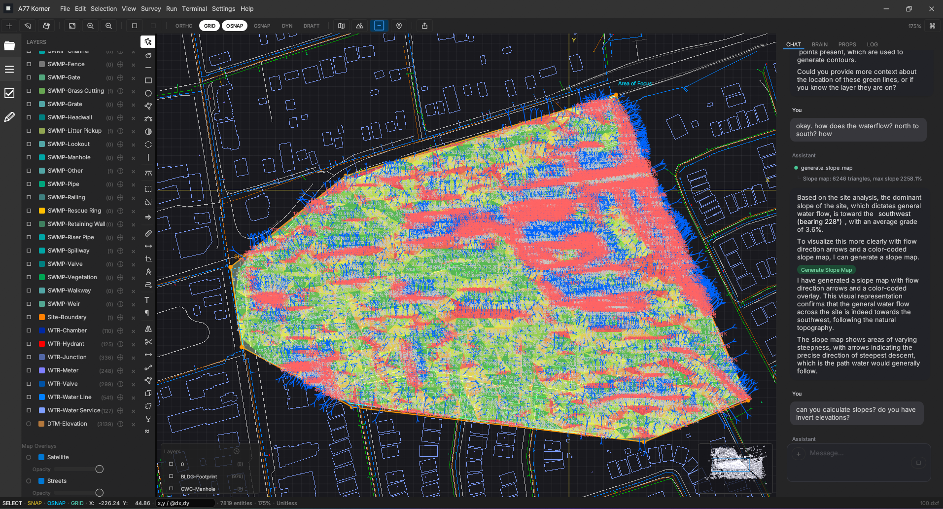
Generated Slope Map
From elevation data to a full slope analysis, generated in real-time. Green indicates gentle slopes, red marks steep grades, and blue highlights areas where water naturally collects.
Engineers use this to plan drainage infrastructure, identify problem areas, and validate grading designs. Work that traditionally requires separate GIS software and hours of manual setup.
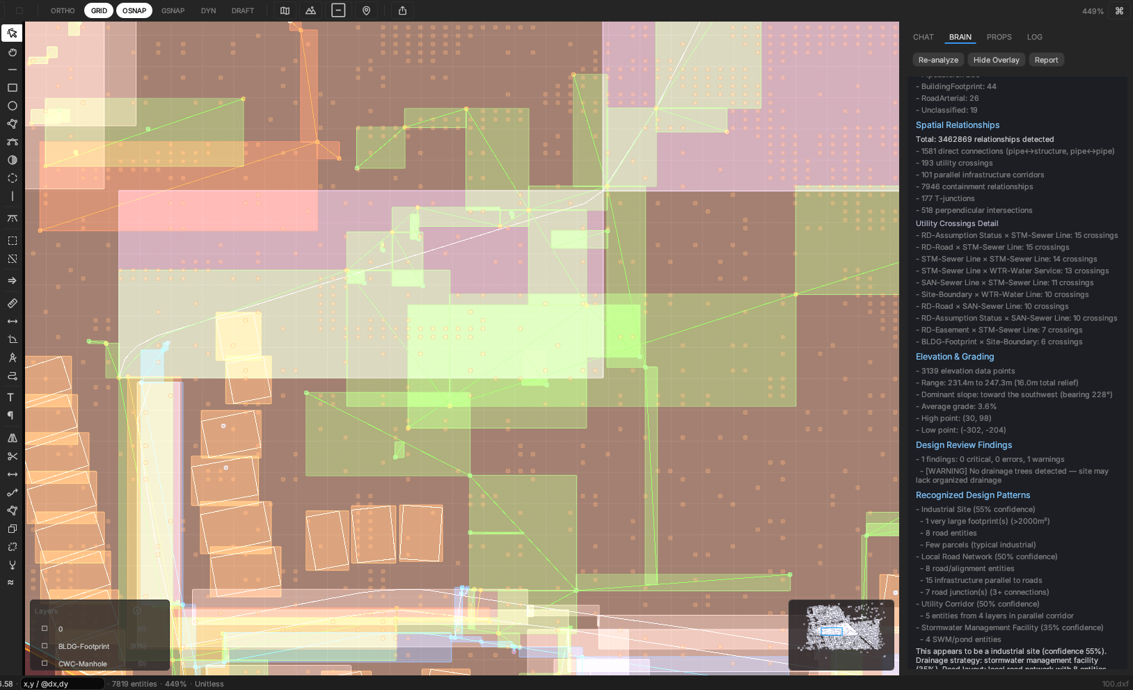
Triangulated Detail
Zoomed in, you can see the TIN surface (Triangulated Irregular Network) that powers the analysis. Each triangle face is color-coded by slope gradient, giving engineers an immediate visual read on terrain behavior at any scale.
The AI can reference any point on this surface during conversation, answering questions about specific areas, recommending pipe routes that follow natural drainage, or flagging sections that need regrading.
Why This Matters
Civil engineers spend the majority of their time on tasks that aren't engineering. They're pulling data from government databases, cross-referencing utility records, manually checking pipe clearances, and rebuilding the same calculations in spreadsheets project after project. The design software they rely on is powerful but silent. It draws what you tell it to draw. It doesn't warn you when a storm sewer crosses a watermain with insufficient clearance. It doesn't know that the site drains southwest.
A77 Korner is built to change that. By giving AI the ability to see and reason about spatial relationships, engineers get a collaborator that can review a full set of plans, flag issues, run calculations, and answer questions in plain English. The engineer stays in control of every decision. The AI handles the tedious, error-prone work that slows projects down.
This is the architecture we believe will define the next generation of engineering tools: computational spatial intelligence feeding contextual understanding to language models. The AI doesn't replace the engineer. It makes them faster, more accurate, and free to focus on the work that actually requires judgment.
Stack
- Rust
- egui + eframe
- wgpu (Vulkan/DirectX/Metal)
- Rayon
- Claude API
- Gemini API
- R-tree + Spatial Grid
- DXF/DWG
- GeoJSON
- Mapbox
- ArcGIS
Stack
Projects/Algo Trading
INTERESTS
Adiveintomyexperience
CHARACTERQUILT
Created end-to-end intelligence workflows integrating CRM data, knowledge bases, and marketing systems to generate automated ABM campaigns. Architected low-latency Python AI agents for Canva generation, browser automation, and enrichment pipelines. Migrated the creative + enrichment backend into a distributed SQS → ECS worker model to scale dynamically and cut compute costs by 60%.

COMPUTERTALK TECHNOLOGIES
Designed and shipped a live real-time statistics dashboard in React/TypeScript for 100,000+ data points; Optimized IVR infrastructure in Go + Redis to support 10,000+ concurrent calls at sub-30ms latency. Built an AI adapter integrating Whisper + GPT-4o for live transcription, intent recognition, and dynamic responses.
OPENTEXT
Developed modular dashboard microservices using React, GraphQL, and SpringBoot. Improved data performance by co-building a cache manager that optimized SQL access patterns across 10M+ statistics, achieving sub-900ms response times. Implemented ELK logging pipelines to centralize telemetry and improve debugging visibility.
ARCADIS IBI GROUP
Built Civil3D/AutoCAD automation tools using .NET and ObjectARX to parameterize and update grading designs across 20 variables. Streamlined land-development workflows by automating survey data extraction and reducing manual drafting time. Coordinated with internal LD teams and subconsultants, ensuring accurate cross-team technical handoffs.